- Products
- Products
- Companies
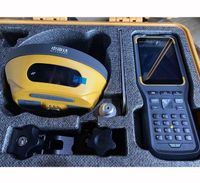
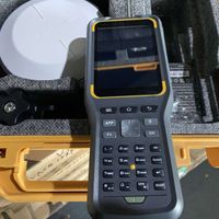
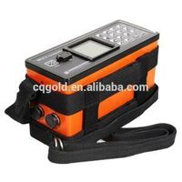
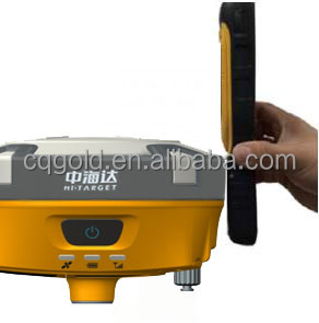
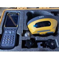
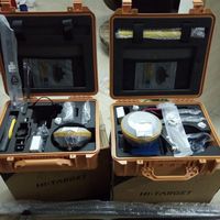
Hi-Target GPS measurement equipment GNSS GPS RTK system in engineering construction

-
Supplier: Chongqing Gold Mechanical & Electrical Equipment Co., Ltd. -
Region: Chongqing, China -
Contact: Ms Michelle Li -
Price: $200.00 /set -
Min. Order: 1 set
Product details
| brand: | Zhong Haida | Satellite support: | GLONASS, GPS, Sbas |
| Packaging Details: | Hi-Target GPS measuring equipment GNSS GPS RTK system in wooden box for engineering construction packing | Customization support: | OEM,ODM,OBM |
| payment terms: | L/C, Western Union, D/P, D/A, T/T, MoneyGram | operating system: | operating system |
| weight: | 1.25 kg | aspect: | 16.4cm*8.35cm |
| Initialization time: | <10s | Warranty: | 1 year |
| waterproof: | IP67 | Origin: | Chongqing, China |
| main application: | surveying and mapping | screen size: | 3.7 inches |
| Initialize reliability: | >99.99% | model: | V96H |
| Supply capacity: | 1000 sets per month | channel: | 220 |
| port: | GNSS GPS RTK system of Hi-Target GPS measurement equipment in Chongqing Zhihang Engineering Construction |
Hi-Target GPS measurement equipment GNSS GPS RTK system in engineering construction

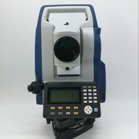
High-precision Hi-Target GPS surveying and mapping equipment GNSS GPS RTK system
This GNSS RTK GPS is widely used in engineering construction and geological surveying and mapping. It is welcomed by the market for its advantages of good quality, favorable price, high precision and light weight.
*Technical parameters of Geodetic V96H GNSS receiver:
Measurement |
220 channels | |
| Advanced Pacific Crest Maxwell 6 Custom Survey GNSS Technology | ||
| High precision GNSS pseudorange correlator | ||
| Unfiltered, low noise, low multipath error, low temporal correlation | ||
| Very low noise GNSS carrier phase measurement with <1mm (1 Hz) accuracy | ||
| Signal-to-Noise Ratio in dB-Ha | ||
| Proven Pacific Crest low-altitude travel technology | ||
| track satellite signal | GPS: L1C/A, L2C, L2E, L5 | |
| simultaneously | GLONASS: L1C/A, L1P, L2C/A (GLONASS M only), l2p | |
| SBAS: L1 C/A, L5 | ||
| Galileo: L1 BOC, E5A, E5B, E5ALtBOC | ||
| Beidou/Compass: B1, B2 | ||
| QZSS: L1 C/A, L1 SAIF, L2C, L5 | ||
| position Performance |
static and fast static | Level: l2.5mm+0.5ppm RMS |
| GNSS measurements | Vertical: l5mm+0.5ppm RMS | |
| post-processing kinematics | Level: 1cm+1ppm RMS | |
| (PPK/stop and go) GNSS measurements |
Vertical: 2.5cm+1ppm RMS | |
| Initialization time: generally 10 minutes | ||
| for the base and 5 minutes for the rover | ||
| Initialization reliability: typically >99.9% | ||
| Real-time Kinematics (RTK) Measurement |
Horizontal.8mm+1ppm RMS | |
| Vertical.15mm+1ppm RMS | ||
| Initialization time typically < 8 seconds | ||
| Initialize reliability. Usually > 99.9% | ||
| Code Differential GNSS position |
Horizontal.25cm+1ppm RMS | |
| Vertical.50cm+1ppm RMS | ||
| SABS: 0.50m horizontal, 0.85m vertical | ||
| hardware | physical | Dimensions (W x H): 18.20cm x 9.80cm (7.17 inches x 3.86 inches) |
| Weight: 1.25kgs (2.76lbs) without built-in battery | ||
| Operating: -45°C to +65°C (-49°F to +149°F) | ||
| storage temperature. -55°C to +85°C (-67°F to +185°F) | ||
| Humidity: 100%, considering | ||
| Waterproof and dustproof. IP67 dustproof, dustproof | ||
| Temporary immersion to a depth of 1 m (3.28 ft) | ||
| shock and vibration. designed for survival | ||
| A 3 m (9.84 ft) high natural drop onto concrete. | ||
| electric | Power supply 6V to 28V DC external power input | |
| Power consumption≤3.5w | ||
| Automatic switching between internal power supply and external power supply | ||
| Rechargeable, removable 7.4V, 5000mAh Li-ion battery | ||
| Batteries in the internal battery compartment | ||
| Internal battery life | Static 13-15 hours | |
| RTK Rover (UHF/GPRS/3G) 10-12 hours | ||
| RTK benchmark 8-10 hours | ||
| input/output interface | 1×Bluetooth | |
| 1×standard USB2.0 interface | ||
| 1×TNC UHF connector | ||
| 2×RS232 serial port | ||
| 2×DC power input (8-pin & 5-pin) | ||
| 1×Micro SD card interface | ||
| communicate & data storage |
3G communication | Fully integrated, fully sealed internal 3G, |
| Compatible with GPRS | ||
| Network RTK (via CORS) range 20-50km | ||
| HI-TRAGERT interior UHF radio (standard) |
Frequency: 450~470MHz 116 channels | |
| Transmission power: 1W, 2W, 5W, adjustable | ||
| Transmission speed: 9.6Kbps, 19.2Kbps | ||
| Working range: typical 5km, best 8-10km | ||
| Pacific Crest XDL Micro Internal UHF radio |
Frequency: 403-473MHz | |
| Transmission power: 0.5W, 2W adjustable | ||
| Transmission speed: up to 19.2Kbps | ||
| Working range: typical 3-5km, best 8-10km | ||
| Hi-Target external UHF radio (standard) |
Frequency: 460MHz 116 channels | |
| Transmission power: 5W, 10W, 20W, 30W adjustable | ||
| Transmission speed: up to 19.2Kbps | ||
| Working range: 8-10km typical, 15-20km optimal | ||
| Pacific Crest ADL Advantages Pro External UHF Radio |
Frequency: 390-430MHz or 430-470MHz | |
| Transmitting power: adjustable from 4W to 35W | ||
| Transmission speed: up to 19.2Kbps | ||
| Working range: 8-10km typical, 15-20km optimal | ||
| Support other external communication equipment |
For example, an external GSM modem. | |
| Data Format | CMR: sCMRx, CMR, CMR+ input and output | |
| RTCM: RTCM2.1 2.2 2.3 3.0 3.1 3.2 input and output | ||
| Navigation output ASCII: NMEA-0183 | ||
| Navigation Output Binary: GSOF | ||
| Output 1 pulse per second | ||
* Features of Geodetic RTK GPS Base Station and Rover:
operating system
ARM 9G20 400MHz CPU, embedded Linux operating system, supports faster data transmission.
Intelligent operation
*Equipped with smart speaker guidance throughout the process. The voice assistant can help you quickly master the operation of V60. Language can be customized.
* The industrial LED display on the front control panel shows all information and working status.
*Multiple one-click operations to make your work easier. Set the base with one click, and automatically select the base coordinates from the base list.
* Automatic system logging to make receiver diagnostics easy.
RINEX Storage
Static data can be directly saved in RINEX format. The V60 is fully compatible with other brands of receivers.
quick upgrade
Simply copy the updated firmware to the V60 and reboot to complete the upgrade in seconds.
Multi-constellation tracking
*220 tracking channels.
*Support GPS, GLONASS, GALILEO, BDS, SBAS.
*Built-in NGS-approved antenna.
High Power Transceiver UHF Radio
* Transceiver UHF radio enables working mode switchable between base station and rover.
*5 watt (max) HI-TARGET internal UHF radio and 2 watt (max) Pacific Crest Micro XDL internal UHF radio are optional
*Pacific Crest TrimTalk© internal UHF radio compatible with other RTKs.
Works seamlessly in the CORS system
*Built-in GPRS/GSM/3G module makes V60 perfectly cooperate with network RTK positioning.
long life battery
*Powered by 5000mAh Li-ion battery.
*Static working time 13 - 15 hours
*RTK Rover(UHF/GPRS/3G) working time 10 - 12 hours
*RTK basic working time 8 - 10 hours
Robust design, IP67
*IP67 Dust/Waterproof.
* Withstands a natural drop of 3 meters onto concrete.
* Fast tracking and perfect avoidance or mitigation of obstacles and multipath effects, ensuring excellent positioning capabilities.

Hi-Target GPS measurement equipment GNSS GPS RTK system in engineering construction
contact us:

VIEW MORE
You may like
-
Factory Price TTR Meter Automatic Transformer Turns Ratio Tester
-
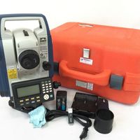
RTK Survey or Static Survey Hi Target GPS GNSS Base and Rover Receiver
-
Zone 6 and Zone 18 metal detection motherboard for arch through metal detection door price
-
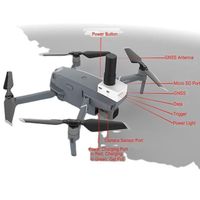
High Accuracy PPK GNSS GPS Receiver for Phantom 4 and Mavic
-
Batch gift Sok kia CX105 IM101 CX55 IM55 CX65 Reflectorless total station test instrument
-
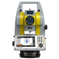
Ready to ship Geo-Maxs Zoom-50, A5 2" Total Station Test Instruments
-
Hi-Target V90 Plus Pro GNSS RTK system measurement gps gnss rtk system
-
Best Super Quality Original Sokkias CX 105 5 Seconds Mirrorless Total Station
-
Promotion price Sokkia CX105 IM101 CX55 IM55 CX65 Reflectorless Total Station Test Instrument
-
Portable electronic EC soil meter EC conductivity test detector EC soil meter indoor plant gardening maintenance
Other Products
-
$100.00 / set
-
$200.00 / set
-
$200.00 / set
-
$5.00 / set
-
$10.00 / set
-
$10.00 / set