- Products
- Products
- Companies
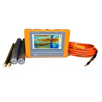
Top 10 Ground water detector Underground water detector PQWT-TC300

-
Supplier: Hunan Puqi Geologic Exploration Equipment Institute (Common Partnership) -
Region: Hunan, China -
Contact: Mr PQWT Manufacturer -
Price: $100.00 /set -
Min. Order: 1 set
| Measuring Frequency: | Single frequency, three frequency and 40 frequency; | Supply Ability: | 150 Set/Sets per Month; |
| Place of Origin: | Hunan China; | Model Number: | PQWT-TC300; |
| LCD Size: | Industrial 7-inch HD Touch Screen; | Power Supply: | DC12V 4000mAh Built-in Battery; |
| Brand Name: | PQWT; | Input Impedance: | ge 10MΩ; |
| Offical Website: | annie(at)pqwtcs.com; | Model No.: | PQWT-TC300 underground water finder; |
| Port: | Changsha; | Payment Terms: | L/C,D/A,D/P,T/T,Western Union,MoneyGram,Paypal; |
| A/D Conversion: | 12-bit 1Msps; | Measurement Accuracy: | 0.001mV; |
| Packaging Detail: | underground water finder is packed in Alumium Specialized Box + Carton; | Instrument Automatic Conversion Range: | 0mV-2000mV; |
| Measuring Depth: | 300m underground water finder; |
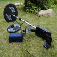
PQWT-TC300 Full Automatic Mapping underground water finder, 300M
Why Choose us
We are the only geographic survey instrument institute in China!
Automatic mapping with one button!!!
Top 10 selling mapping with one button underground water detector!!
Real professional manufacturer of top 10 mapping with one button underground water detector!
With Patent and ISO9001:2008 certificate

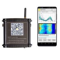
PQWT-TC300 geophysical prospecting mapping with one button underground water detector utilize the natural electric field as working electromagnetic field source, based on the resistivity differences of underground rock , ore or groundwater, measure natural electric field on the ground of N different frequencies electric field component. According to their different variation to study the abnormal changes which is caused by different geological bodies ,to solve the geological problems of a kind of electrical prospecting method.
PQWT-TC300 natural electric field a key to mapping geophysical prospecting underground water detector is our latest research and development of products, using a number of patented technologies. The instrument weight is very light to carry easily , the measuring line need only 10 meters, one person will be able to complete the operation, saving manpower, full touch screen, simple operation, external high-capacity memory card, with the function of real-time mapping with only one button, finding high resistance (fault zone), low resistance (such as water, mining census) through real-time mapping directly display geological abnormal on the measuring site. After data collection by the unique built-in computing functions, the instrument can automatically draw curve graph and profile map with only one button, according to the profile map, you can clearly understand the geological structure and quickly determine the location of ore body (seam), hollow (cave), water (aquifer) etc.


PQWT-TC300 Full Automatic Mapping underground water finder, 300M


PQWT-TC300 Full Automatic Mapping underground water finder, 300M

PQWT-TC300 Full Automatic Mapping underground water finder, 300M


Is it difficult to operate and make the graph?
The instrument is easy to operate, you can find the share how-to video on Youtube
(URL: https://www.youtube.com/watch?v=YPxKh3UIV3c) , and we will send you the detailed operation manual via email. If you have some basis of computer operating, generally it only need 2hour to manage it.

PQWT-TC300 Full Automatic Mapping underground water finder, 300M

PQWT-TC300 Full Automatic Mapping underground water finder, 300M

-
MD5008 3-5M depth metal detector dual probe plate gold silver copper metal hunter

-
2022 Hot Selling Metal Detector Gold Detector GP Pointer Accurate Positioning Handheld Metal Detector
-
DETETOR GPZ 7000 GOLD cheap for sale
-
Original Titan GER 1000 Device 5 System Underground Gold Metal and Cheap Treasure
-
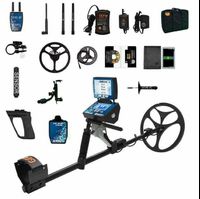
Wholesale Original GER Detect Titan 1000 Metal Detector 3D 5 Multi System Deep
-
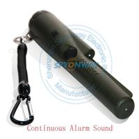
Lowest Price Handheld Metal Detector Professional Pointer Big Promotion Metal Detector Locator Detector PIN POINTER Accurate Positioning
-
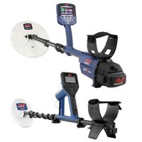
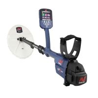
Genuine Underground Minelab GPZ 7000 Gold Metal Detector
-
Hot selling underground metal detector GC1028 treasure detector mining non-ferrous metal gold mine archaeological detector
-
Factory Price Handheld Professional Gold Treasure Hunter Pointer Metal Detector
-
MD5008 3-5M Deep Gold Metal Detector Double Detector Gold, Silver and Copper Metal Hunter
Other Products
-
$399.00 / set
-
$539.00 / set
-
$489.00 / set